
Destinations & habitats
Corsica’s Posidonia Meadows: Reading the Gaps Between the Leaves
A fibrous step beside Corsica’s ribbon-like seagrass reveals the meadow below the leaves, while a bare lane raises a question that one photograph cannot settle.
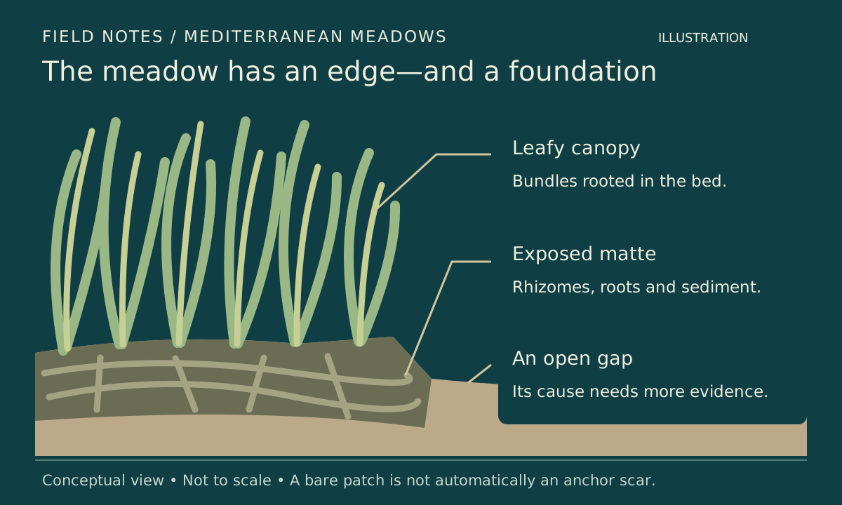
The leafy canopy and the raised, root-filled ground belong to the same habitat. A bare gap alone does not establish how it formed. Original explanatory illustration, not a photograph or measured cross-section. 1 2
Graphic: SeaLifeWiki. Research basis · Original SeaLifeWiki graphic. Original code-native conceptual meadow-edge composition. No photograph or published figure was copied or traced. Not to scale and not a map or reconstruction of a Corsican study patch.
Where Corsica’s ribbon-like seagrass ends beside a bare patch, look for a dark, fibrous step beneath the leaves. That edge matters because the green canopy is only the upper part of a Posidonia meadow: a structure made by the plants can remain after the leaves disappear.
Posidonia oceanica is a Mediterranean seagrass, a flowering plant rather than an alga. Its buried stems, roots and trapped sediment build a layer called matte. A gap can expose that layer, but the view is not automatically an anchor scar or a verdict on the whole meadow. Off north-western Corsica, recent research followed individual gaps repeatedly to separate changing edges from a single impression. The useful encounter begins with three things that can share one view: attached leaves, fibrous ground and open space. 1 2
The meadow continues below the green blades
From above, a meadow may look like one continuous green surface. Near an edge, the separate bundles become easier to follow: long, flat leaves meet at a base rather than branching like a frond of seaweed. The Andalusian environment authority’s field guide describes the ribbon leaves, parallel veins and woody stems of Posidonia. Those features provide a starting point for identification without pulling a plant apart. A leaf moving across the view is less informative than a bundle whose connection to the bottom remains visible. 3
Below those bundles lies the part that gives an exposed edge its thickness. A rhizome is a stem, not a root; in Posidonia, rhizomes and roots interweave with sediment to form matte. Older material can persist after it dies. That explains why a leafless ledge can still hold the shape of a former meadow. The visible difference between leafy top and fibrous side is more useful here than an attempt to assign the ledge an age by eye. 1
The comparison needs an oblique view, not a hand clearing away the cover. From a position that leaves room for the fins, a diver can retain the leaf bases, the side of the ledge and the adjacent bottom in one frame. A top-down close-up of blades alone loses that relationship. The aim is not to expose a textbook cross-section; it is to recognise the parts that the existing edge already makes visible.
Loose brown ribbons tell a different story from a bare patch with no attached shoots. Posidonia sheds leaves, and its appearance changes through the year. The institutional field guide describes autumn leaf loss and shorter leaves in winter and early spring. A layer of fallen blades is therefore not, by itself, evidence that the rooted meadow has died. In a November view, the useful distinction is between litter lying across the bottom and living bundles still connected beneath it. 3
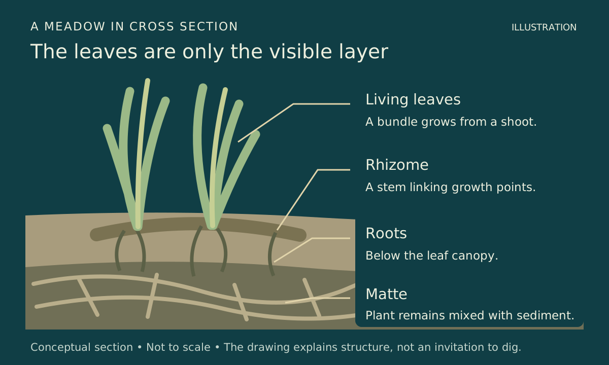
A rhizome is a stem. Together with roots and accumulated sediment, it helps make the matte beneath the blades. The drawing separates parts that should remain undisturbed underwater. Original schematic, not to scale. 1 3
Graphic: SeaLifeWiki. Research basis · Original SeaLifeWiki graphic. Original code-native conceptual anatomy diagram, not to scale. No research figure or photograph was copied or traced; no specimen was collected or exposed.
A bare lane is a clue, not a verdict
A narrow break through the leaves can look like a track. The immediate questions are concrete: does it expose sand, a fibrous ledge, or both? Are leaf bundles present along its sides? Does the opening continue beyond the frame? Recording those features preserves more information than giving the gap a cause before its surroundings have entered the picture.
Anchoring can remove Posidonia shoots. In an experiment at Ustica, an island north of Sicily, researchers tested three anchor types through dropping, dragging to set and retrieval. Their 2004 paper found that the type of anchor and the stage of anchoring affected damage, with retrieval especially important. The connection to an underwater view is mechanical: an anchor that catches plant material can lift it when raised. The experiment does not supply a reliable way to date or identify every bare lane from its outline. 4
Natural openings also belong in the explanation. The Corsican study describes a large sandy feature in Alga Bay associated with near-bottom circulation; the broader assessment literature recognises naturally patchy meadow forms. A smooth expanse of sand between leaves therefore cannot establish anchoring by itself. Conversely, uncertainty about one opening does not erase the damage measured in anchoring experiments. The sensible field note keeps what is visible separate from the proposed cause. 1 2
A wide photograph can include the lane, both edges and a stable landmark outside the plants. A second frame can describe the substrate more closely without contact. Together they answer different questions: where the opening lies, and what its surface looks like. Neither needs an arrow labelled damage unless there is evidence for that interpretation. A sharper-looking edge in one photograph can also reflect a changed camera angle or leaves lying in a different direction.
New green is not yet a repaired meadow
At Alga Bay, near Calvi in north-western Corsica, Boulenger and colleagues returned to six study sites between May 2022 and May 2024. They used overlapping photographs to build three-dimensional models and follow natural recolonisation in degraded anchoring areas. Three sites lay at 20 metres and three at 28 metres. Those are research depths, not a promise that the same study patches sit within a snorkeler’s view. 2
Their repeated models showed erosion as well as recolonisation. Changes at the 20-metre sites were more variable; the deeper sites changed more slowly and steadily. Natural return did not compensate for the degradation on the study’s timescale. That result gives a small green margin a useful context: a shoot extending into a gap and the gap becoming a recovered meadow are different claims. The depth comparison belongs to these sites and observations, not to a universal rule that every deeper meadow recovers more slowly. 2
The researchers also recorded loose plant fragments and algae on exposed matte. Both matter when a previously bare area looks greener. A detached leafy fragment may be resting on the bottom, while an alga can cover ground without replacing the seagrass structure. From a non-contact view, the helpful record identifies the visible form and its apparent connection to the substrate. It does not turn every green strand into an established Posidonia shoot. 2
A repeat photograph becomes useful when the same fixed features can be recognised. A rock beside the patch is a better reference than a drifting blade. Keeping the date, depth and broad viewing direction with the picture allows a later comparison to begin in the right place. If the first image shows only the green edge and the second only the sand, a claim about movement has lost its common reference. Observation can remain worthwhile without pretending to reproduce a research survey.
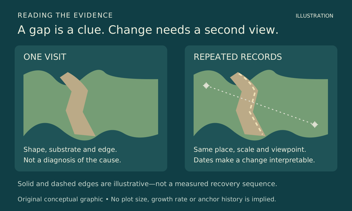
One view records an edge. Repeated, aligned observations can test change; the dashed outline is illustrative, not a measured growth result. Original explanatory graphic. 2
Graphic: SeaLifeWiki. Research basis · Original SeaLifeWiki graphic. Original evidence comparison with independent shapes and labels; no borrowed figure, mapped outline or measured result. Dashed edges illustrate repeat-view alignment rather than reported growth.
A route over the leaves, not through them
The edge offers a close view without becoming a place to settle. Clearance needs to follow the moving leaf tips, not just the apparent height of the bottom. A diver who hovers above the matte but sweeps fins through the canopy has not left the whole plant clear. The archive’s fin-wash guide explains how body position and kick direction change the disturbance below; here, the visible check is whether the blades remain outside that movement.
For a snorkeler, a shallower meadow can provide the same comparison from the surface: attached bundles, an opening and the material at its edge. Standing in the gap to get a photograph changes the observation and may place feet on shoots that are hard to distinguish beneath litter. A route that requires landing, holding the plants or squeezing through their canopy offers too little room for an undisturbed view.
A loose fragment need not become a planting project. The Corsican research distinguishes transported fragments from established recolonisation, and its restoration discussion rests on measured site conditions. Leaving material where it lies preserves that distinction. A photograph and a location shared with a relevant local monitoring programme can carry an observation away without taking a plant or rearranging its patch. Boat arrangements and access should follow current local guidance rather than a guessed anchoring rule inferred from the view below.
On the next Mediterranean dive, the meadow’s edge can remain in the picture a little longer. The blades show the canopy, the fibrous lip shows the ground the plants helped build, and the open patch gives the eye a comparison. The gap does not have to surrender its entire history for that view to become more legible.
Sources & further reading
- Personnic and colleagues (2014): An Ecosystem-Based Approach to Assess the Status of a Mediterranean Ecosystem, the Posidonia oceanica Seagrass Meadow — Open-access primary framework and field assessment. Supports shoot and matte anatomy, persistent dead matte and naturally patchy meadow forms. No published figure is reproduced.
- Boulenger and colleagues (2025): Assessing Posidonia oceanica recolonisation dynamics for effective restoration designs in degraded anchoring sites — Primary two-year photogrammetry study in Alga Bay, Calvi, Corsica, May 2022–May 2024; three sites at 20 m and three at 28 m. Author-institution full text: https://orbi.uliege.be/bitstream/2268/330686/1/Boulenger2025.pdf. Results describe these measured patches, not a Mediterranean-wide recovery rate.
- Junta de Andalucía, LIFE Posidonia: Las praderas de posidonia y tú — Scientific-institutional field explanation in Spanish: ribbon-leaf identification, stems and roots, leaf replacement and seasonal appearance. Photographs on the institutional page are not reused.
- Milazzo and colleagues (2004): Boat anchoring on Posidonia oceanica beds in a marine protected area (Italy, western Mediterranean): effect of anchor types in different anchoring stages — Primary Ustica experiment distinguishes anchor types and anchoring stages, including damage during retrieval. Full text: https://www.vliz.be/imisdocs/publications/54789.pdf. The article does not recommend an anchor type or extrapolate the experiment into damage per boat visit.
Read next
- Scotland’s Maerl Beds: Why the Pink “Gravel” Is Alive
Look for pink branches among pale seabed fragments in western Scotland: the living surface and the gaps beneath it make a habitat worth keeping clear of your fins.
- Green sea turtles in the Florida Keys: reading a seagrass encounter
Watch a green turtle’s beak, its route through the grass, and its next breath to distinguish feeding from resting during a Florida Keys encounter.
- Why Your Scuba Fins Stir Up Sand Even When You Hold Depth
If sand rises behind your fins while your depth stays steady, check your body angle and the water your kick sends toward the bottom—not just whether you are sinking.